


açıklaması Pix4Dcapture
Pix4Dcapture turns your consumer drone into a professional drone mapping tool. A free companion to Pix4D photogrammetry software, Pix4Dcapture is the perfect tool to automatically capture image data - RGB, thermal - for optimal 3D models and maps. Process post-flight images easily on the cloud or desktop applications, producing georeferenced maps and models that are tailored to many industry needs.
Currently, the app supports and was tested for the following drones:
• DJI
- Phantom 4 Pro v2.0
- Phantom 4 Pro
- Phantom 4
- Mavic 2 Pro
- Mavic Pro
- Mavic Air
- Matrice 200
- Matrice 210
- Matrice 210 RTK
- Inspire 2
- Inspire 1 (Pro)
- Phantom 3 Professional
- Phantom 3 Advanced
- Phantom 3 Standard
- Matrice 100
- Spark
• Parrot
- Anafi with Skycontroller 3
- Anafi Thermal with Skycontroller 3 (RGB + Thermal Images)
- Bluegrass with Skycontroller 2
- Bebop 2 with Skycontroller 2
• Yuneec
- H520 with E90 camera and ST16S controller (compatible version available from support page)
Features and benefits:
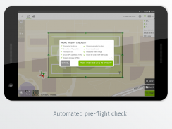
- Fully automated drone mapping
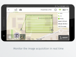
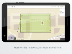
- Drone telemetry and camera live feed during the image acquisition
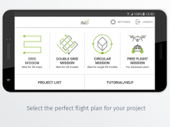
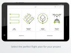
- Different flight plans for different needs
- Polygon Mission for general mapping
- Grid Mission for general mapping
- Double Grid Mission for better 3D model reconstruction
- Circular Mission for point-of-interest 3D model reconstruction
- Free Flight Mission for vertical object mapping with manual flight control
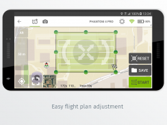
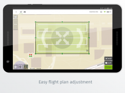
- Flight parameters for each mission - front & side image overlap, camera angle, altitude,
flight speed - can be adjusted based on the requirements of the area.
- Save or duplicate missions to fly the same area of interest several times
- Combine several missions into one project in the project manager
- Precise mission planning by importing KML/KMZ files
- Store the basemap with your flight plan using offline maps
- Change street/satellite basemap provider
- Seamless workflow with Pix4D’s processing software
- Automated image transfer from drone-to-device
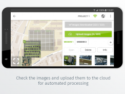
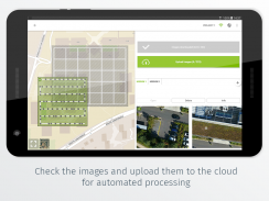
- Upload images directly from the device to Pix4D software in the cloud for processing (license required)
Post-flight processing & analysis using Pix4D’s software on cloud or desktop:
- Achieve survey-grade results from lightweight and compact cameras to large-frame metric cameras
- Usage of Ground Control Points (GCPs) for improving the relative and absolute accuracy of the model
- Generate and modify
- Point clouds
- Orthomosaics
- Digital elevation models (DSM/DTM)
- Index maps (e.g. NDVI)
- And more
- Measure distances, surfaces, and volumes
Important information:
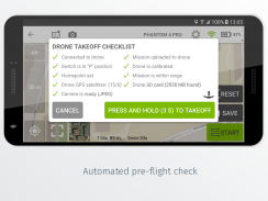
Ensure you have the latest firmware installed on your drone and the app is up to date. The app follows the flight plan and does not avoid obstacles automatically. Pix4D accepts no liability for damage, injuries or legalities from the misuse of this app. Use only in safe environments.
Pix4Dcapture, tüketici drone'nuzu profesyonel bir drone haritalama aracına dönüştürür. Pix4D fotogrametri yazılımına ücretsiz bir arkadaş olan Pix4Dcapture, optimum 3D modeller ve haritalar için görüntü verilerini (RGB, termal) otomatik olarak yakalamak için mükemmel bir araçtır. Uçuş sonrası görüntüleri kolayca bulut veya masaüstü uygulamalarında işleyerek, birçok endüstri ihtiyacına göre uyarlanmış coğrafi referanslı haritalar ve modeller üretir.
Şu anda uygulama aşağıdaki dronları destekliyor ve test edildi:
• DJI
& nbsp; - Phantom 4 Pro v2.0
& nbsp; - Phantom 4 Pro
& nbsp; - Hayalet 4
& nbsp; - Mavic 2 Pro
& nbsp; - Mavic Pro
& nbsp; - Mavic Air
& nbsp; - Matrice 200
& nbsp; - Matrice 210
& nbsp; - Matrice 210 RTK
& nbsp; - İlham 2
& nbsp; - İlham 1 (Profesyonel)
& nbsp; - Phantom 3 Professional
& nbsp; - Phantom 3 Gelişmiş
& nbsp; - Phantom 3 Standardı
& nbsp; - Matrice 100
& nbsp; - Kıvılcım
• Papağan
& nbsp; - Skycontroller 3 ile Anafi
& nbsp; - Skycontroller 3 ile Anafi Termal (RGB + Termal Görüntüler)
& nbsp; - Skycontroller 2 ile Bluegrass
& nbsp; - Skycontroller 2 içeren Bebop 2
• Yuneec
& nbsp; - E90 kamera ve ST16S denetleyicili H520 (uyumlu sürüm destek sayfasından edinilebilir)
Özellikler ve avantajlar:
& nbsp; - Tamamen otomatik drone eşleme
& nbsp; - Görüntü edinme sırasında drone telemetrisi ve kamera canlı yayını
& nbsp; - Farklı ihtiyaçlar için farklı uçuş planları
& nbsp; & nbsp; - Çokgen Görev genel haritalama için
& nbsp; & nbsp; - Genel haritalama için Izgara Görevi
& nbsp; & nbsp; - Daha iyi 3D model rekonstrüksiyonu için Çift Izgara Görevi
& nbsp; & nbsp; - İlgi çekici 3B modelin yeniden yapılandırılması için Dairesel Görev
& nbsp; & nbsp; - Manuel uçuş kontrolü ile dikey nesne eşleme için Serbest Uçuş Görevi
& nbsp; - Her görev için uçuş parametreleri - ön & amp; yan görüntü çakışması , kamera açısı , yükseklik ,
& nbsp; & nbsp; & nbsp; & nbsp; & nbsp; uçuş hızı - alanın gereksinimlerine göre ayarlanabilir.
& nbsp; & nbsp; & nbsp; - Aynı ilgi alanını birkaç kez uçmak için Kaydet veya çift görev
& nbsp; & nbsp; & nbsp; - Birkaç görevi proje yöneticisinde tek bir projede birleştirin
& nbsp; & nbsp; & nbsp; - KML / KMZ dosyalarını içe aktararak kesin görev planlama
& nbsp; & nbsp; & nbsp; - Temel haritayı çevrimdışı haritalar kullanarak uçuş planınızla birlikte saklayın
& nbsp; & nbsp; & nbsp; - sokak / uydu temel haritası sağlayıcısını değiştirin
& nbsp; & nbsp; & nbsp; - Pix4D’nin işleme yazılımı ile sorunsuz iş akışı
& nbsp; & nbsp; & nbsp; & nbsp; - drone'dan cihaza otomatik görüntü aktarımı
& nbsp; & nbsp; & nbsp; & nbsp; - Görüntüleri doğrudan cihazdan işleme için buluttaki Pix4D yazılımına yükleyin (lisans gerekir)
Uçuş sonrası işleme & amp; bulutta veya masaüstünde Pix4D’nin yazılımını kullanarak analiz:
& nbsp; - Hafif ve kompakt kameralardan büyük çerçeveli metrik kameralara kadar anket kalitesinde sonuçlar elde edin
& nbsp; - Modelin göreceli ve mutlak doğruluğunu geliştirmek için Yer Kontrol Noktaları (GSİO) kullanımı
& nbsp; - Oluştur ve değiştir
& nbsp; & nbsp; - Nokta bulutları
& nbsp; & nbsp; - Ortomosikler
& nbsp; & nbsp; - Dijital yükseklik modelleri (DSM / DTM)
& nbsp; & nbsp; - Dizin haritaları (ör. NDVI)
& nbsp; & nbsp; - Ve dahası
& nbsp; - mesafeleri , yüzeyleri ve hacimleri ölçün
Önemli bilgiler:
Drone'nuzda en son ürün yazılımının yüklü olduğundan ve uygulamanın güncel olduğundan emin olun. Uygulama uçuş planını takip eder ve otomatik olarak engellerden kaçınmaz. Pix4D, bu uygulamanın yanlış kullanımından kaynaklanan hasar, yaralanma veya yasallık için hiçbir sorumluluk kabul etmez. Yalnızca güvenli ortamlarda kullanın.
Pix4Dcapture - Sürüm 4.11.0
(13-07-2021)Pix4Dcapture - APK Bilgisi
APK sürümü: 4.11.0Paket: com.pix4d.pix4dmapperAynı kategorideki uygulamalar
Hoşuna gidebilecekler...


